Louisiana Weather and Climate
Geography of Louisiana and Its Impact on Weather
The surface of Louisiana can be divided into two parts, the uplands of the north, and the alluvial areas along the coast. The alluvial region includes low swamp lands, coastal marshlands and beaches, and barrier islands.
The higher and contiguous hill lands of the north part of the state have an area of more than 25,000 square miles. They consist of prairie and woodlands.
Elevations in the state range from sea level at the Gulf, to 535 feet above sea level at Driskell Mountain near Ruston.
Typical Louisiana Weather Patterns and Climate
Louisiana has a humid subtropical climate, with long, hot, humid summers and short, mild winters. Precipitation is frequent throughout the year, although the summer is slightly wetter than the rest of the year. Rainfall and humidity decrease, and daily temperature variations increase with distance from the Gulf.
In the summer, the extreme maximum temperature is much warmer in the north than in the south, with temperatures near the Gulf occasionally reaching 100 °F, although temperatures above 95 °F are commonplace. In northern Louisiana, the temperatures can sometimes reach near 105 °F in the summer.
Temperatures are generally mildly warm in the winter in the southern part of the state, with highs around New Orleans, Baton Rouge, the rest of south Louisiana, and the Gulf averaging 66 °F, while the northern part of the state is mildly cool in the winter with highs averaging 59 °F. Snow is rare, but parts of the state can experience snowfall in winter.
Louisiana is often affected by tropical cyclones and is very vulnerable to strikes by major hurricanes. The entire state averages over 60 days of thunderstorms a year, more than any other state except Florida. Louisiana averages 27 tornadoes annually.
Louisiana High and Low Record Temperatures
The highest temperature on record was 114 degrees, measured on August 10, 1936 in Plain Dealing, in extreme northwest Louisiana near Shreveport. The lowest temperature was -16 degrees, recorded on February 13, 1899 in Minden.
Current Louisiana Weather Conditions, Weather Radar, and Forecast as Reported in the Center of the State at Alexandria (courtesy of Accuweather)
Current U.S. Weather Map from the National Weather Service
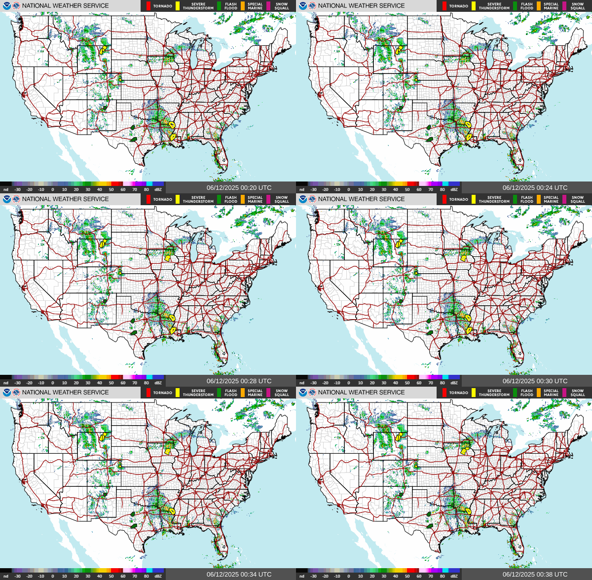
Current Gulf of Mexico Radar

Active Weather Alerts from the National Weather Service


Current U.S. Temperatures (Weather Channel)

Saffir-Simpson Hurricane Wind Scale
A Tropical Depression is a tropical cyclone in which the maximum sustained surface wind speed is 38 mph or or less.
A tropical cyclone is named as a Tropical Storm when its wind reaches 39mph sustained.
A cyclone reaching 74mph is classified as a Hurricane.
The Saffir-Simpson Hurricane Wind Scale is a 1 to 5 rating based on a hurricane's sustained wind speed. This scale estimates potential property damage. Hurricanes reaching Category 3 and higher are considered major hurricanes because of their potential for significant loss of life and damage.
| Category | Strength in MPH |
| 1 | 74-95 |
| 2 | 96-110 |
| 3 | 111-129 (Major) |
| 4 | 130-156 (Major) |
| 5 | 157 or greater (Major) |
Past Tropical Hurricane Impacts in Louisiana
Louisiana cities and towns along the Gulf coast, and those further inland, have been impacted by major hurricanes for centuries. The earliest recorded hurricane was in October of 1527, striking the mouth of the Mississippi River.
The 1856 Last Island hurricane (or Great Storm of 1856) was a deadly and destructive tropical cyclone that is tied (as of 2021) with Hurricane Laura and Hurricane Ida as the strongest hurricane on record to make landfall in Louisiana, measured by maximum sustained winds. This hurricane, in today's nomenclature, was a powerful Category 4 storm.
These major tropical storms have caused catastrophic damage, from Slidell and New Orleans, to Grand Isle, Pine Island, Cameron and other towns in between.
From 2000 to the present, at least 37 tropical storms or hurricanes have affected Louisiana. It is reported that a tropical cyclone makes landfall along the Louisiana coast about two times every three years, and a hurricane makes landfall once every 2.8 years.
Growing up, and living in Louisiana, we clearly remember the names, like Audrey, Andrew, Katrina, Rita, Gustav, Betsy, Ida and many more. Some of the storms and experiences are still in our minds ...
Hurricane Audrey - 1957
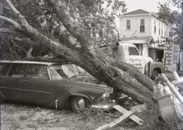 Hurricane Audrey damage in south Louisiana in 1957 (Photo courtesy of the Louisiana Digital Library) |
The deadliest natural disaster in the history of Southwest Louisiana, Hurricane Audrey, struck the coast during the early morning hours of June 27, 1957. An early season hurricane named Audrey roared ashore into Southwest Louisiana and Southeastern Texas. It was the only storm to reach Hurricane Category 4 status in June.
The eye of Audrey made landfall south of Sabine Lake, crossed the lake and then passed over Bridge City, Texas. Audrey spread a massive storm surge across most of Cameron parish, and across the southern halves of Vermilion, Iberia, and St. Mary parishes, causing total devastation in property and many lives lost.
Damage in Louisiana was catastrophic, with 60-80% of the homes and businesses from Cameron to Grand Chenier being either destroyed or severely damaged.
Hurricane Audrey ranks as the 7th deadliest hurricane to strike the United States in modern times, with at least 500 deaths. The exact number will never be known, as many perished in the storm surge in Cameron and Vermilion parishes, and many missing persons were never found.
Hurricane Betsy - 1965
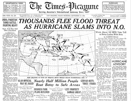 Hurricane Betsy news in September of 1965 |
Hurricane Betsy's most severe impacts were felt in Louisiana, where it made landfall as a powerful Category 4 hurricane in 1965.
Betsy slammed into New Orleans on the evening of September 9, 1965, where 110 mph winds and power failures were reported. The cyclone pushed damaging storm surge into Lake Pontchartrain, breaching levees in New Orleans and inundating several neighborhoods, most notably the lower Ninth Ward. Strong winds caused widespread power and telecommunications outages across the region.
Further inland, effects wrought by Betsy were considerably weaker, although there was heavy rainfall in Louisiana as far north as Ruston.
Hurricane Andrew - 1992
Hurricane Andrew was a powerful and destructive Category 5 Atlantic hurricane that struck the Bahamas, Florida, and Louisiana in August of 1992.
Prior to making landfall in Louisiana on August 26, Andrew caused extensive damage to oil platforms in the Gulf of Mexico, leading to $500 million in losses for oil companies. It produced hurricane-force winds along its path through Louisiana, damaging large stretches of power lines that left about 230,000 people without electricity.
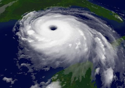 Hurricane Katrina in the Gulf of Mexico in 2005 |
Over 80% of trees in the Atchafalaya River basin were downed, and the agriculture in the region was devastated. Even Baton Rouge, miles inland from the Gulf, suffered significant tree and power line damage.
Hurricane Katrina - 2005
Hurricane Katrina was a Category 5 tropical cyclone that occurred in August of 2005, causing over 1,800 deaths and $125 billion in damage, particularly in the city of New Orleans and the surrounding areas.
The storm formed as TD12 on August 23 in the Bahamas, made a landfall near Hallandale, Florida, and moved into the Gulf. Over the warm Gulf it rapidly intensified from Category 3 status to Category 5 on August 28, in just nine hours.
The cyclone reached its peak strength with maximum sustained winds of 175 mph and a minimum central pressure of 902 mbars. It weakened to Category 3 strength at its landfall on August 29, 2005, over southeast Louisiana and Mississippi.
Storm surge from Hurricane Katrina resulted in multiple levee failures in the New Orleans area, flooding approximately 80% of the city, with some places being inundated by more than 15 feet of water.
Hurricane Rita - 2005
Hurricane Rita was the fourth-most intense Atlantic hurricane ever recorded, and the most intense tropical cyclone ever observed in the Gulf (as of that time).
Rita became a Category 5 cyclone on the Saffir-Simpson Hurricane Scale on September 21, with peak winds of 180 mph, with a low pressure of 895mbars.
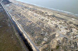 Holly Beach, Louisiana, devastation from Hurricane Rita (Photo courtesy of FEMA) |
A weakened Rita made landfall on September 23, 2005, between Sabine Pass, Texas, and Johnsons Bayou, Louisiana, as a Category 3 hurricane with 115 mph winds.
The storm then pushed through parts of southeast Texas. However, the Louisiana coast bore the brunt of the destruction from the stronger northeast quadrant of the hurricane.
The storm surge caused extensive damage along the Louisiana and extreme southeastern Texas coasts and destroyed some coastal communities.
Several parishes were hard hit, but Cameron Parish was hit the hardest with the towns of Creole, Cameron, Grand Chenier, Johnson's Bayou, and Holly Beach (see photo above right) being totally demolished.
Rita caused as estimated $12 billion in damage along the U.S. Gulf Coast.
Hurricane Gustav - 2008
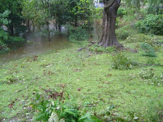 Hurricane debris and flooding in Baton Rouge (Louisiana Destinations Staff Photo) |
Due to the threat of significant storm flooding associated with the landfall of a major hurricane along the Louisiana Coast, widespread evacuations took place in south Louisiana from August 29-31, 2008. Estimates indicate that 1.9 million people evacuated from south Louisiana in advance of Hurricane Gustav.
The storm made landfall near Cocodrie, Louisiana, about 70 miles southwest of New Orleans, on Labor Day morning, September 1, 2008, as a strong Category Two Hurricane with sustained winds of 110 mph. Gustav continued to move inland across south-central Louisiana as a hurricane, then dropping to tropical storm status.
Wind damage was significant in areas from the south-central coast of Louisiana through greater Baton Rouge with this hurricane. Power was knocked out for days, some areas longer, across this region, with numerous trees down and other related wind damage. A peak wind speed of 91 mph was reported at Ryan Field in Baton Rouge, 108 and 117 mph near Houma, Louisiana, and 72 mph at Belle Chasse Naval Air Station.
Storm surge was a significant problem in parts of Mississippi and Louisiana as Gustav moved onshore. At Bay St Louis in Hancock County, Mississippi, water levels were nearly 10 feet above normal.
A total of 34 Louisiana parishes were declared disaster areas as a result of Gustav.
Hurricane Laura - 2020
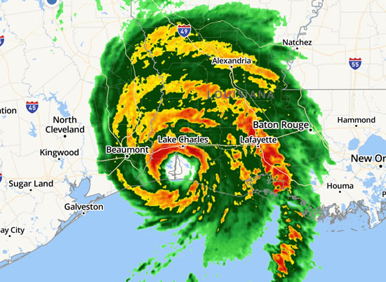
Hurricane Laura came ashore near Cameron, Louisiana, early in the morning of August 27, 2020, as a Category 4 storm with 150 mph winds and a low pressure of 937mb. It built a 10-foot storm surge in Cameron and surrounding areas.
Gulf Coast areas that were struck by Laura were affected again six weeks later by Hurricane Delta.
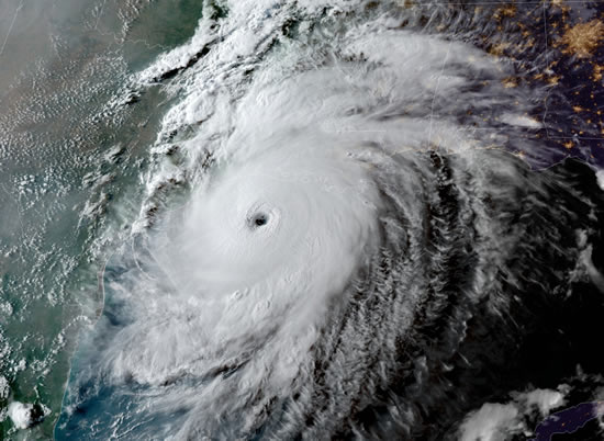 Hurricane Laura in the Gulf (August 26, 2020) |
Hurricane Laura at landfall (August 27, 2020) |
Hurricane Ida - 2021
Hurricane Ida at landfall (August 29, 2021) |
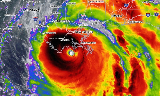
Hurricane Ida came ashore near Grand Isle and Port Fourchon, Louisiana, at mid-day on August 29, 2021, as a high-end Category 4 storm with winds of 150 mph and a pressure of 929mb.
Ida became the second most intense hurricane on record (as of 2021) to strike the State of Louisiana, behind Hurricane Katrina (2005). It also tied for the strongest landfall in the state in terms of maximum winds with Hurricane Laura (2020) and the Last Island Hurricane (1856).
The cyclone originated from a tropical wave first monitored by the National Hurricane Center (NHC) on August 23, 2021.
Ida caused massive flooding and structural damage in Houma, LaPlace, Slidell, Grand Isle and many other south Louisiana communities. The hurricane knocked out power to more than a million homes and businesses in Louisiana and Mississippi, including all of New Orleans. About 440,000 people in 17 parishes were left with no drinking water, and an additional 320,000 were under boil-water advisories. Shortages of other commodities such as ice and gasoline were widespread.
More About Louisiana Hurricane History
David Roth of the National Weather Service in Camp Springs, MD, has written a detailed account of Louisiana hurricanes in the 18th, 19th, 20th and 21st centuries.
Read the document about the history of Louisiana hurricanes (PDF)
Hurricane Naming and Retired Hurricane Names
In 1953, the United States began using female names for storms.
Beginning in 1978, men's and women's names were included in the Eastern North Pacific storm lists. In 1979, male and female names were included in lists for the Atlantic and Gulf of Mexico. View the list of retired hurricane names at the National Hurricane Center (NHC)
Shown below are the names for Atlantic hurricanes in 2023-2028.

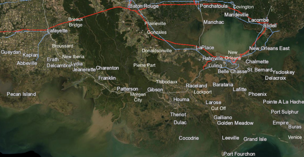
Map of Cities & Towns along the Louisiana Gulf Coast
The map below shows cities and towns along the Louisiana Gulf Coast ... from Gueydan eastward to Buras, and from Baton Rouge southward to Grand Isle and Port Fourchon. Also shown are other cities of interest such as Houma, LaPlace, and New Orleans.
